
NAME
r.futures.devpressure - Module for computing development pressureKEYWORDS
raster, filter, statisticsSYNOPSIS
Flags:
- -n
- Do not propagate nulls
- --overwrite
- Allow output files to overwrite existing files
- --help
- Print usage summary
- --verbose
- Verbose module output
- --quiet
- Quiet module output
- --ui
- Force launching GUI dialog
Parameters:
- input=name [required]
- Name of input binary raster map representing development
- output=name [required]
- Name of the output development pressure raster
- method=string [required]
- Method for computing development pressure
- Options: occurrence, gravity, kernel
- Default: gravity
- occurrence: number of developed cells in window
- gravity: scaling_factor / pow(distance, gamma)
- kernel: scaling_factor * exp (-2*distance / gamma)
- size=integer [required]
- Half of neighborhood size
- Default: 8
- gamma=float
- Coefficient controlling the influence of distance, needed for method gravity and kernel
- Default: 1.5
- scaling_factor=float
- Scaling factor needed for method gravity and kernel
- Default: 1
- nprocs=integer
- Number of threads for parallel computing
- 0: use OpenMP default; >0: use nprocs; <0: use MAX-nprocs
- Default: 0
Table of contents
DESCRIPTION
Module r.futures.devpressure is part of FUTURES, land change model. It computes development pressure, a predictor based on the number of neighboring developed cells within search distance, weighted by distance. The development pressure variable plays a special role in the model, allowing for a feedback between predicted change and change in subsequent steps.There are multiple options for calculating development pressure in the model.
- occurrence: simple count of the number of developed cells within the specified window size
- gravity: defined as scaling_factor / pow(distance, gamma)
- kernel: defined as scaling_factor * exp(-2 * distance / gamma)
Coefficient gamma is the coefficient controlling the influence of distance. The best value for gamma is chosen during the model selection process (TODO).
The input raster is binary, value 1 represents development, value 0 no development. The neighborhood size describes the size of the moving window in cells (2 * size + 1).
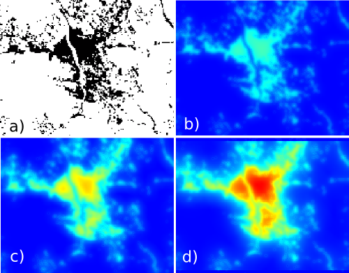
Figure: Effect of parameters size and gamma: a) initial development, b) gamma = 2, size = 10, c) gamma = 1.5, size = 10, d) gamma = 1.5, size = 20.
NOTES
By default NULL values are propagated. This means that the edges of the resulting map will be NULLs. To avoid that, flag n internally enlarges the computational region, converts NULLs to zeros, performs the computation and then patches back the original NULL values.Module r.futures.devpressure, although written for FUTURES model, is general enough to be used for different applications where distance pressure can be described with the functions above.
EXAMPLES
r.futures.devpressure input=developed output=pressure gamma=1.5 size=10 method=gravity
REFERENCES
- Meentemeyer, R. K., Tang, W., Dorning, M. A., Vogler, J. B., Cunniffe, N. J., & Shoemaker, D. A. (2013). FUTURES: Multilevel Simulations of Emerging Urban-Rural Landscape Structure Using a Stochastic Patch-Growing Algorithm. Annals of the Association of American Geographers, 103(4), 785-807. DOI: 10.1080/00045608.2012.707591
- Dorning, M. A., Koch, J., Shoemaker, D. A., & Meentemeyer, R. K. (2015). Simulating urbanization scenarios reveals tradeoffs between conservation planning strategies. Landscape and Urban Planning, 136, 28-39. DOI: 10.1016/j.landurbplan.2014.11.011
- Petrasova, A., Petras, V., Van Berkel, D., Harmon, B. A., Mitasova, H., & Meentemeyer, R. K. (2016). Open Source Approach to Urban Growth Simulation. Int. Arch. Photogramm. Remote Sens. Spatial Inf. Sci., XLI-B7, 953-959. DOI: 10.5194/isprsarchives-XLI-B7-953-2016
- Sanchez, G.M., A. Petrasova, A., M.M. Skrip, E.L. Collins, M.A. Lawrimore, J.B. Vogler, A. Terando, J. Vukomanovic, H. Mitasova, and R.K. Meentemeyer (2023). Spatially interactive modeling of land change identifies location-specific adaptations most likely to lower future flood risk. Sci Rep 13, 18869. DOI: 10.1038/s41598-023-46195-9
SEE ALSO
FUTURES, r.futures.simulation, r.futures.parallelpga, r.futures.potential, r.futures.potsurface, r.futures.demand, r.futures.calib, r.futures.gridvalidation, r.futures.validation, r.sample.categoryAUTHORS
Corresponding author:
Anna Petrasova, akratoc ncsu edu,
Center for Geospatial Analytics, NCSU
Original standalone version:
Ross K. Meentemeyer,
Wenwu Tang,
Monica A. Dorning,
John B. Vogler,
Nik J. Cunniffe,
Douglas A. Shoemaker
(Department of Geography and Earth Sciences, UNC Charlotte)
Jennifer A. Koch
(Center for Geospatial Analytics, NCSU)
Port to GRASS and GRASS-specific additions:
Vaclav Petras,
NCSU GeoForAll
Development pressure, demand, calibration, validation, preprocessing tools and maintenance:
Anna Petrasova,
NCSU GeoForAll
Climate forcing submodel:
Anna Petrasova,
NCSU GeoForAll
Georgina Sanchez,
Center for Geospatial Analytics, NCSU
Zoning:
Margaret Lawrimore,
Center for Geospatial Analytics, NCSU
Anna Petrasova,
NCSU GeoForAll
SOURCE CODE
Available at: r.futures.devpressure source code (history)
Accessed: Sunday Sep 13 08:28:50 2026
Main index | Raster index | Topics index | Keywords index | Graphical index | Full index
© 2003-2026 GRASS Development Team, GRASS 8.5.1dev Reference Manual