
NAME
r.dem.stats - Compute terrain surface metrics used as DoD predictorsKEYWORDS
raster, DEM, terrain, statistics, geomorphologySYNOPSIS
Flags:
- -e
- Also compute Shannon evenness (metric=diversity_shannon)
- --overwrite
- Allow output files to overwrite existing files
- --help
- Print usage summary
- --verbose
- Verbose module output
- --quiet
- Quiet module output
- --ui
- Force launching GUI dialog
Parameters:
- input=name [required]
- Input DEM (or DoD raster for metric=error_sigma_local)
- output=name [required]
- Output surface-metric raster
- metric=string [required]
- Surface metric to compute
- Options: slope, roughness_std, diversity_geomorphon, diversity_shannon, error_sigma_local
- window=integer
- Moving window size in cells (odd integer >= 3)
- Default: 7
- log_base=string
- Logarithm base for Shannon diversity
- Options: e, 2, 10
- Default: e
- slope_format=string
- Output format for slope
- Options: degrees, radians
- Default: degrees
Table of contents
DESCRIPTION
r.dem.stats computes terrain surface metrics from a DEM (or a DEM of Difference). The outputs are the predictor rasters used to model terrain-correlated DoD uncertainty and systematic bias, for example as inputs to r.dem.bias or as an uncertainty source for r.dem.errprop.
A single metric is selected per run through the metric option:
- slope: surface slope from r.slope.aspect, in degrees or radians as selected with slope_format (default degrees).
- roughness_std: local roughness as the Gaussian-weighted focal standard deviation of elevation (r.neighbors).
- diversity_geomorphon: landform category richness in a moving window, computed from r.geomorphon forms.
- diversity_shannon: local Shannon diversity
H' = -sum(p * log(p))over category proportions in a window, computed from a categorical input such as a geomorphon forms map. The logarithm base is selected with log_base (e,2, or10; defaulte). With the -e flag the matching Shannon evennessJ = H' / log(S)is also written as<output>_evenness. - error_sigma_local: a robust local standard deviation via the
median absolute deviation,
sigma = 1.4826 * median(|x - median(x)|)in a moving window. Use a DoD raster as input to obtain a spatially varying DoD uncertainty surface.
NOTES
The window must be an odd integer of at least 3 cells. Focal metrics use a Gaussian weighting whose falloff is derived from the window radius, matching the focal behavior used throughout the DoD workflow.
For diversity_shannon the input is expected to be categorical (integer
classes). A natural pairing is to first compute a geomorphon forms map and then
run r.dem.stats with metric=diversity_shannon on that
map.
Intermediate rasters are removed on exit. The tool honours the current
computational region and the --overwrite flag.
EXAMPLES
The commands below use the example scene built in the r.dem toolset manual, which is derived from the North Carolina sample dataset. Build it there first.
Derive the terrain predictors used by r.dem.bias method=regression and as diagnostic surfaces:
g.region raster=elev_lid792_1m

r.dem.stats input=elev_lid792_1m output=slope metric=slope
r.dem.stats input=elev_lid792_1m output=roughness \
    metric=roughness_std window=13
r.dem.stats input=elev_lid792_1m output=landforms \
    metric=diversity_geomorphon window=13
The slope metric is r.slope.aspect under the tool's own naming, so the two agree cell for cell.
metric=diversity_shannon needs a categorical map rather than an elevation surface, so derive the geomorphon forms first and run the metric on those. The -e flag adds the matching evenness raster:
r.geomorphon elevation=elev_lid792_1m forms=landform_classes \
    search=7 flat=4

r.dem.stats -e input=landform_classes output=landform_diversity \
    metric=diversity_shannon window=13
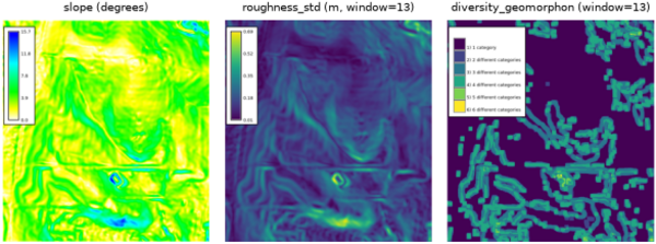
Figure: Slope, roughness, and geomorphon diversity on the lidar reference.
SEE ALSO
r.dem, r.dem.bias, r.dem.errprop, r.geomorphon, r.neighbors, r.slope.aspectAUTHORS
Corey T. White, Center for Geospatial Analytics, NC State University
SOURCE CODE
Available at: r.dem.stats source code (history)
Accessed: Sunday Sep 13 08:28:15 2026
Main index | Raster index | Topics index | Keywords index | Graphical index | Full index
© 2003-2026 GRASS Development Team, GRASS 8.5.1dev Reference Manual